


A staggering 8.8‑magnitude earthquake struck off the coast of Russia’s Kamchatka Peninsula on July 30, sending tsunami waves rippling across the Pacific and raising alarms over potential structural damage to one of the nation’s most sensitive military installations. The tremor—among the six strongest ever recorded—triggered evacuations, caused injury, and was followed by a rare volcanic eruption, illustrating the deep interplay between tectonics, climate, and strategic security.
I. The Tremor and Tsunami: A Pacific Alarm
The quake’s epicenter lay roughly 120–149 km east of Petropavlovsk‑Kamchatsky at a shallow depth of about 17–21 km. Aftershocks as strong as magnitude 6.9 followed. In Severo‑Kurilsk, tsunami waves—measured up to six meters high—flooded the fishing port and damaged a kindergarten. Tens of residents and tourists were evacuated, and several injuries were reported, though none critical.
Coastal Japan and Hawaii issued tsunami warnings, prompting evacuations in affected zones. Western U.S. states observed advisory protocols as far away as Chile and French Polynesia.
Authorities cited swift response protocols and earthquake-resistant infrastructure as key to why there were no confirmed fatalities, praising regional alert systems and citizen compliance.
II. Strategic Fallout: Is the Nuclear Fleet at Risk?
The quake has drawn global scrutiny due to potential damage sustained at the Rybachiy submarine base, home to Russia’s Pacific Fleet nuclear-capable submarines. Satellite imagery reviewed by The New York Times and other outlets revealed that a floating pier may have separated from its anchorage. Though no further structural collapse is evident, military observers suggest implications for readiness and nuclear safety cannot be dismissed. Russia’s defense ministry has offered no comment.
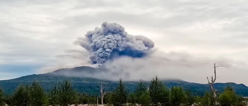
III. Volcanic Awakening & Climate Convergence
Within days, Krasheninnikov Volcano, located in the Kronotsky Reserve, erupted—its first confirmed activity in 600 years, according to Russia’s volcanic monitoring authorities; other estimates place its last eruption closer to 1550. The eruption followed a magnitude 7.0 aftershock and expelled ash nearly 6 km into the stratosphere, though ashfall did not affect populated areas.
Scientists believe this eruption may have been directly triggered by the seismic event: tectonic slippage along the megathrust fault also activated volcanic magma pathways converging beneath Kamchatka’s active volcanic belt.
IV. Geological Context: A Region Built on Fire and Ice
Kamchatka lies along the infamous Ring of Fire, where the Pacific Plate is subducted beneath the North American Plate—an interaction that produces megathrust earthquakes periodically. Historical events include the 1952 Severo‑Kurilsk 9.0 quake, which triggered a regional tsunami causing widespread destruction. The July 2025 quake ranks closely in scale and potential impact.
V. Human Response and Lessons Learned
Despite its strength, the disaster’s low casualty toll reflects decades of preparedness: mandatory building codes, seismic modeling, and community education. Hospitals, schools, and infrastructure were quickly inspected, and authority-managed evacuations proved largely effective.
However, regional officials remain cautious as aftershocks continue. Russia has declared states of emergency across parts of Kamchatka and the Kuril Islands, signaling sustained monitoring and precautionary measures.
The Takeaway
This event underscores the complex vulnerabilities at the intersection of geology and geopolitics. A natural disaster not only provoked humanitarian fears across the Pacific but also raised unresolved security questions for nuclear infrastructure—while simultaneously awakening a dormant volcano. As global risks converge, even sparsely populated regions like Kamchatka offer lessons on preparedness, resilience, and the unpredictable power of nature.